Tides on Planet Earth

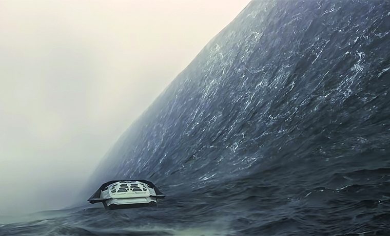
Main image: Trying to escape the ‘tide’ in the movie Interstellar – Warner Brothers. For those who have not seen the movie, the tide scene can be viewed at www.youtube.com/watch?v=F6C1Nk1YbnE
Meteorologist Malcolm Riley reflects on the gravitational effect of heavenly bodies on Tides on Earth and Planet Miller
In the movie Interstellar, a spacecraft goes to the planet Miller to rescue the missing Dr Miller, the planet’s is namesake. Miller is a planet entirely covered by water, in the main shallow (knee deep), and this is an interesting theoretical planet to reflect on tides. The tides on Miller are caused by a nearby planet Gargantua that exerts gravitational forces, in much the same way our sun does. The huge gravitational pull of Gargantua makes for tides of about 1,200 metres – around the same height as kunanyi/Mt Wellington in Hobart.
In the movie this tide arrives as a single steep-faced wave, rather than over time like our tides, and the standing tide wave is moving relative to the surface of the planet not relative to Gargantua; the same as tides caused by our sun.
In a nutshell the gravitational pull of Gargantua makes a standing wave (a bulge) on the surface of Miller and the planet Miller rotates underneath this ‘wave’. The shallowness of the water (most of the time) is a function of the huge tidal bulge and the majority of the planet’s water is contained in the huge wave. If the wave was not there or was smaller, the overall depth of water on the planet would be greater. If you are interested in physics, Interstellar is the movie for you, and there are plenty of online sites where the physics shown in the movie are debated.
Similar tidal processes happen here on Earth, however the forces are a lot smaller and subsequently so are the tidal effects. To understand what is going on, for now I will remove all land from the Earth and make the sea depth uniform.
The forces in play are the gravitational pull of the sun and the moon causing bulges in the sea (high tide) that form more or less where the Earth’s face is closest to the sun and moon. But there are two more bulges that form on the opposite side of the Earth, also caused by the sun and moon’s gravity, but in a different way. These two bulges (high tides) are formed by centrifugal force. When you are a passenger in a car taking a sharp turn, you are pressed to the outside of the car. Much the same happens with the second tides.

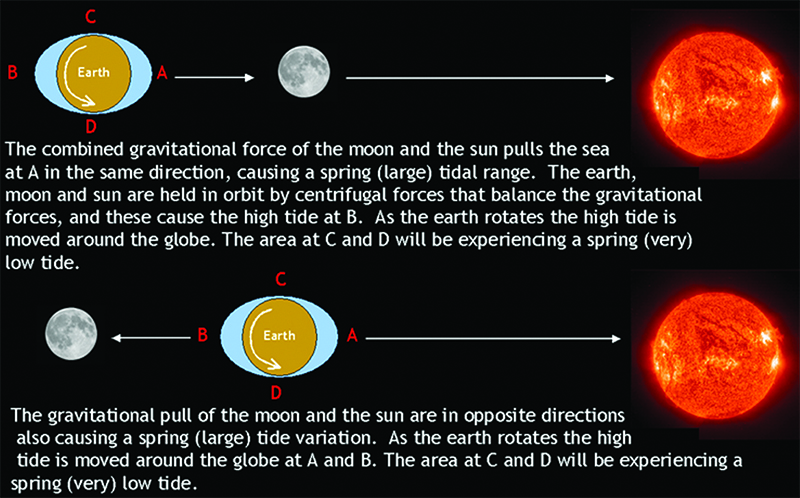
The gravitational pull of the moon and sun vary with the distance between them and the Earth. The moon is the major driver of Earth’s tides. The moon on average is 384,400km away from Earth, but its orbit of Earth is elliptical. When the moon is closest (Perigee) it is about 356,500km away and when it is furthest away (Apogee) it is about 406,700km. The changes in distance affect the tidal range on Earth. A super moon is a full moon that more or less coincides with Perigee, when it appears to the human eye about 14% larger than at Apogee.
Perigee and Apogee occur once each approximately every four weeks and are two weeks apart. The closer the moon is to the Earth, the greater the gravitational force exerted by the moon on the Earth, and the larger the tides. The moon rotates around the Earth once every 24 hours and 50 minutes. Time differences between two high and two low tides caused by the moon would occur about 12 hours and 25 minutes apart. Due to the greater than 24 hours orbit, the tide would retard approximately 50 minutes per day.
The sun also exerts a gravitational force on the Earth, nearly 200 times more force than the moon, however the solar effect on tide is about 50% that caused by the moon. This is due to the sun being so much further away and the uniform nature of the sun’s ‘pull’. The Earth’s orbit of the sun is also elliptical. When the Earth is closest to the sun (Perihelion), which occurs in January, it is about five million kilometres closer than when it is furthest away (Aphelion), which occurs in July. Solar influence of the tides is enhanced near Perihelion. The Earth rotates around the sun every 24 hours. If there was no moon and we just had solar tides, there would be high tides (local time) at midnight and noon and low tides at 6am and 6pm every day, everywhere in the world.
The moon orbiting the Earth causes high and low tides and the Earth’s rotation around the sun causes a separate two high and low tide regimes. When they align, the tide ranges are generally larger (spring tides) and when they not in alignment the tide ranges are smaller. When the moon and sun have the greatest misalignment, this causes the smallest tide ranges (neap tides).
Both the sun and the moon’s gravity distort the shape of the Earth by about 30cm: something like an Earth rather than a water tide. But the Earth also exerts a gravitation pull on the moon, distorting the surface. This distortion causes heat – I suppose much like bending a wire backwards and forwards. Jupiter’s moon Lo gets distorted so much that the heat generated by the distortion makes Lo the most volcanic body in our solar system. This process is called tidal heating.
Back to our planet and ocean tides. When you add back in the land masses and different depths of the ocean, it all gets really complex. The water tends to slop about in a series of tidal basins, but still more or less giving two high and two low tides per day over much of our oceans.
Why all this talk of tides? Well, a reader asked the following question:
With global warming now in full swing, glaciers melting as well as sea ice and rising sea levels, how will the increase in sea levels be reflected in future tide charts?
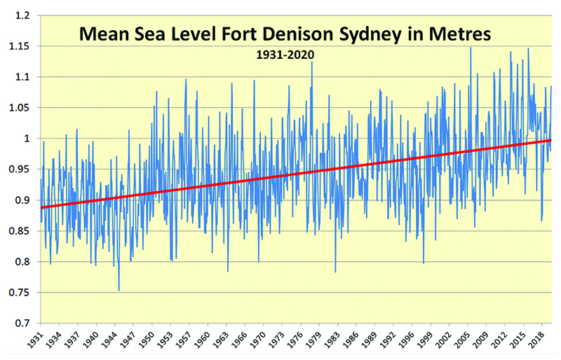
Before this is explained, in Australia the charts and tide heights are calculated from a chart datum – the lowest astronomical tide (LAT). The chart datum currently in use is the LAT 1982-2011 epoch. The sea level is rising, and the two main causes are thermal expansion (the oceans expanding as the sea gets warmer) and glacial and polar ice melt. NASA has calculated that the world’s oceans are increasing in height by 3.1mm per year.
Rest assured the authorities who deal with this in Australia and around the world are on to it. The Bureau of Meteorology, responsible for calculating the official tide heights in Australia, has been adding about 3mm per year to the tides, due to sea level rise. The Bureau will continue to add this, or another figure if the rate increases or decreases in the future. Over a 30 year period for example, tide heights would increase by about 90mm. Interestingly the 2010-12 La Niña event saw a 5mm drop in global sea level as more evaporated water rained over the land than normal.
The Hydrographic Office, which issue navigation charts, are also aware of the sea level rise. Their chart datum is the 1982-2011 epoch for LAT. So if you had an obstruction (a rock) of say two metres depth showing on your chart, which is at LAT, to calculate the depth you would encounter this rock on any given day at, you need to add the tide prediction at the time you are moving over the rock. If you were moving over the rock at high tide and the prediction for the day was 1.4 metres then you would have 3.4 metres of water depth. As the Bureau adds the sea level rise into their tide figures, you more or less need to keep doing what you have been to calculate safe depth, by using navigation charts and tide predictions.
The Hydrographic Office may, at some point in the future, decide to change the LAT epoch to a new one. If they do, the charts will change to reflect the new LAT and this will be done in conjunction with the Bureau of Meteorology, which will in turn adjust its tide predictions. When, and if this happens, there will be notifications in Notices to Mariners on the navigation charts and the tide table publications. This would be a huge task and charts would not all change at once. But relax, it may not happen for decades yet.
Indigenous Australians had a good understanding of the moon and tides. One group in northern Australia thought that as the tides increase, the water pours into the moon as it rises, ultimately creating a full moon when it is full of water. As the moon wanes, the water runs out of the moon and the tides fall. This is a different understanding to ours but still very practical knowledge.
The tides were very important for Australia’s original peoples, as food was often gathered in the shallows and intertidal zones. You needed to know when to go to a certain part of the coast to successfully access the food. For some Indigenous groups, the sun was a woman covered in ochre carrying a torch while the moon was a fat lazy man.