Weather: Interpret – Adjust – Prepare

Weather forecasts are never going to be perfect. As mariners, it is our responsibility to interpret, adjust, and prepare.
Technology is transforming our reception of weather forecasts. They are improving with more weather observations, satellites scanning the earth faster, and greater resolution.
The multitude of options by way of weather apps could be seen as an improvement, but often the choice is overwhelming. Which weather forecasting can we rely upon? To understand this properly and make an informed decision we need to look at how our forecasts are created.
The World Meteorology Organization manage a programme called the World Weather Watch. To predict the weather modern meteorology depends upon near instantaneous exchange of weather information across the entire globe. Established in 1963, the World Weather Watch combines observing systems, telecommunication facilities, and data processing and forecasting centres. This is operated by Members, to make available meteorological and related environmental information needed to provide efficient weather services in all countries. Australia’s Bureau of Meteorology (BOM) is a Member.
The BOM’s forecasts are constructed for each state and territory from a blend of Australian and international models using the latest science, technology, and expert meteorologist input aimed at better representing our local weather. The forecasts are collected centrally in the Australian Digital Forecast Database (ADFD) which is a collection of official weather forecast elements, such as temperature, rainfall, and weather types. Forecasters assemble information from historical forecasts and current observations as well.
Accuracy
Forecasting accuracy is not simple. Each forecaster has their expertise area that could be wind, temperature, rain, or storms. Analysis relies on humans, their ability, their expertise, timing, and geographical region – these all change between longer and shorter timeframes.
Online forums are great for information – also great for misinformation. Weather is a hot topic in sailing forums and disgruntled sailors often ask, “Why are the weather forecasters so wrong?” They aren’t, but not all forecasts are equal. Whichever app or technology you use, you must research how they compile their forecasts.
Some forecasters can access more information than others. Different algorithms are used as are different forecasting models. Some apps will just churn out a computer model’s predictions, other apps will employ a meteorologist to correct and update these predictions (and some won’t). App creators choose what they show, some will simplify the information while others will include as much as they can. I’ve even read that the expectations of recipients can influence some forecasts!
In my experience, the most reliable forecasts are from The BOM.
But you have to be reliable too. You should understand the basics of weather, have an open mind, be prepared and apply different sources, and take into account local weather patterns.
On their website, the Bureau of Meteorology Marine Wind Forecast Maps clearly state:
“These maps display data from a single computer model. Please note they may be different to the Bureau’s official products including local and coastal waters forecasts, tropical cyclone warnings, and MetEye which consider other sources of information and are fine-tuned by meteorologists.”
And we must remember:
“Please be aware that wind gusts can be 40 percent stronger than the average wind speeds presented here, and stronger still in thunderstorms and squalls.”
Australia’s Weather Observing Stations
The BOM collects weather data from different types of observing stations. Stations are located around Australia, on offshore islands, and in the Antarctic. These stations are chosen based on a range of constraints. The stations are a mix of staffed premises, automatic weather stations, meteorological satellites, drifting ocean buoys, ships, and aircraft.
There are over 870 BOM weather stations throughout the country. They are fitted with instruments measuring wind, rain, temperature, and humidity. Some log measurements every minute, while others record values daily.
At some locations Bureau staff supplement ‘visual’ observations, such as temperature, humidity, pressure, and wind with observations of cloud and other elements, for example, sea state. These manual observations are reported less frequently. Mostly, three hourly instrument readings are made up of temperature, air pressure, humidity, rainfall, and windspeed/direction, while visual observations consist of cloud cover and visibility. Temperature and humidity of the upper atmosphere are also obtained by balloon-borne instruments to an altitude of 25 kilometres
http://www.bom.gov.au/climate/data/stations/about-weather-station-data.shtml
Advise from Experience
While competing in the Melbourne to Hobart race I watched Windyty. I liked its simplicity and ease of use. I also studied the synoptic charts from the BOM so I could see why and how the rapid weather changes were happening.
During our cruising life, we downloaded synoptic charts all over the world, via HF radio for free. It’s a great service. The National Oceanic and Atmospheric Administration (NOAA) provide the WeatherFaxes for HF Radio. Setting up your aerial for optimum performance does take time and expense, but then it’s done and that avoids costly monthly internet or satellite plans and you have a great radio.
Over the years and miles, we’ve learned a lot about different aspects of synoptic charts, for example: isobars with a tiny kink means a bit of a slap. Usually, brief, but a sting none-the-less. Troughs and ridges also invariably led to some type of discomfort.
We could see how the systems moved, how they pushed and shoved other systems and changed the forecast. We shared our weather information with other cruisers who employed different systems. Often their weather was more localised, it was interesting to compare and analyse. Here’s one occasion where we shared weather ‘Occluded Fronts and Associated Stunts’ podcast.
https://sistershiptraining.com/cruising-dreams-into-reality/podcasts/.
Local Weather Patterns
As the land changes temperature throughout the day a pattern of land and sea breezes is created along the coast. The pattern occurs as follows:
Sea Breeze
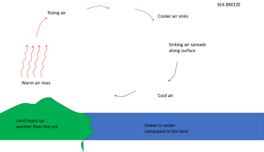
During the day, the sun heats the land. The air is in contact with the land and so is heated too and as this air is heated it rises. The air above the water remains cooler and therefore flows onto the land replacing the warm (heated) air that has risen. This is called a sea breeze: the wind that flows from the sea. Maximum strength of the sea breeze occurs about mid-afternoon. As the heat goes out of the day the sea breeze will lessen towards the evening. With minimal pressure gradient, the sea breeze will generally average 15-18 knots and will not extend more than 20 miles from the coast.
Land Breeze
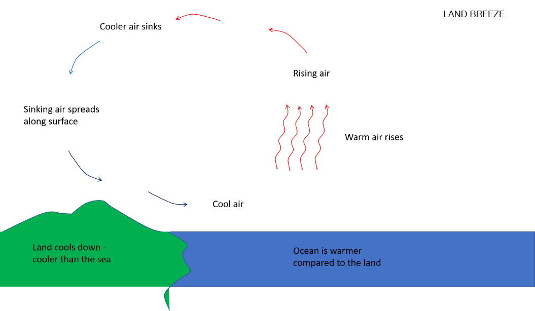
At night, the opposite effect occurs. The land cools down and so the cool air flows downhill from the land and out to sea. This displaces the comparatively warmer air over the water. This land breeze (from the land) is usually gentle (about 4-6 knots) and does not usually extend more than 5-10 nautical miles out to sea.
The Effect of Land And Sea Breezes On Gradient Wind – What It Means to Us
Forecasts refer to prevailing winds, it’s up to us to account for the land affects when coastal sailing, i.e. the sea breeze and land breeze.
When the prevailing wind is light a land or sea breeze can counteract it. In strong prevailing winds the land or sea breeze can cause a noticeable effect.
Coastal waters forecasts will often mention trade winds being ‘lighter inshore at night and in the early morning’. As evidence of this effect, late at night in the moonlight look for low level clouds moving much faster than the air speed at ground level would suggest.
Other considerations are downbursts and katabatic winds, marry these up, as well as land or sea breezes, and the forecast weather can be heavily influenced by local patterns and topography.
Frustration
It can be frustrating when more wind turns up than predicted, also when less turns up too. But it is the fluid, dynamic local conditions that can affect the picture. In your location forecasters can have difficulty providing exact local predications in a general forecast.
This quote from Peter Neilley (scientist, executive, and meteorologist) sums it up nicely:
“To know everything about the weather you would need to model every single particle in the atmosphere and all interactions between them. That isn’t even theoretically possible, because the computer doing the modelling would generate heat and become part of the system, and then need modelling. Putting a thermometer in the air changes conditions a tiny bit. So no, weather forecasts will never be perfect.” Peter Neilley
It is up to us as mariners to analyse, interpret, compare and prepare – after all, you’re the Skipper you’re responsible.
Additional information
DOWNBURST: A severe localised downdraft of wind from a cumulonimbus or towering cumulus cloud. The outward burst of air creates damaging winds at or near the earth’s surface. The term microburst is used to describe a downburst which causes damage over an area with horizontal dimensions of less than four kilometres.
KATABATIC WINDS: Katabatic wind is from the Greek translation Katabaino, which means ‘to go down’. They are downflowing winds from high elevations such as mountains. They are caused by forces that are the result of temperature differences induced by the local topography.
Jackie Parry wrote this article for Pantaenius Sail & Motor Yacht Insurance
Jackie is a Commercial Skipper/Professional Mariner, ex-Marine Rescue Skipper, previous TAFE Maritime Teacher and current Instructor of Professional Level Courses privately (Navigation/E-Charts/Passage Planning/Weather/Intro into Boating). Cert 4 Trainer, Recreational Sailor (ocean sailing around the planet, inland waterways, sailboats and motorboats), Author of Practical Maritime Books/Pilot Books/Memoirs/Articles, Speaker at Nautical and Book Events. https://sistershiptraining.com/
Pantaenius Sail & Motor Yacht Insurance prides itself on providing service with a passion. In a time where most marine insurers have no one in their offices that have any marine specific knowledge, the team at Pantaenius are all uniquely equipped to provide help and assistance to almost all the questions boaters may ask! www.pantaenius.com.au phone: 02 9936 1670
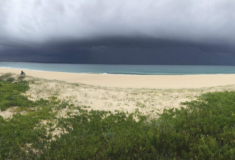
Main photo by Kevin Green